Showing posts with label Albuquerque. Show all posts

Saturday, April 30, 2011

Understanding Bus Rapid Transit


Conversations about mass transit frequently dissolve into a debate about "bus vs. train." Jared Walker from Human Transit talks extensively about this problem here. He also talks about specific differences between bus and rail transit and provides easy to read charts here.

To give a very brief summary of his posts, the perception of rail is generally better only because most rail stops by our house more often (frequency), does not have to share space with cars (designated right of way) and does not stop too often, moving faster. The point he makes is that all of these elements can be a part of a bus network!

Bus rapid transit (BRT) is a new term for a new, but rapidly growing, type of transit system.

If you have never heard of bus rapid transit, or you are not sure how it works, you should watch the video below. It will change your whole perception of bus transportation:

Bus Rapid Transit in Guangzhou, China from Streetfilms on Vimeo.


This video demonstrates that rapid bus networks can work like modern subway train networks. For this reason, bus rapid transit is sometimes called a "surface subway".

It can be hard to envision a system like this working in places such as Tucson or Albuquerque. However, the use of this technology is growing rapidly. One of the primary reasons is lower cost.

Average cost per mile - Light Rail transit: $34.8 million
Average cost per mile - Bus Rapid transit: $13.5 million
(Source: US General Accounting Office, p. 4 - PDF)

A good example of a mid size American city with BRT is Eugene, OR. Learn more about their successful network here.

In an era with limited funds and growing transit needs, Bus Rapid Transit has much potential. Making our busy commercial car corridors into places where someone can walk will be difficult. Bus Rapid Transit can be a strong step in the right direction.

Personal Updates:
This post is Post #50 on this blog. I will try to continue posting frequently. I have recently learned that for a portion of this summer, I will be working for NM Senator Jeff Bingaman in Washington DC. I am excited to spend time exploring the new DC bike sharing network, as well as the wonderful mass transit system in the area. I have continued working with the Living Streets Alliance; it has been fun and rewarding. I look forward to the bright future.

Thanks for reading!

Monday, March 7, 2011

The Central Avenue Corridor, Albuquerque, NM


In my GEOG 416E geovisualization class, we recently completed a lab. The premise of this lab was based on comparing the properties of Google Map/Google Earth vs. ArcGIS as geovisualization tools. For my project, I decided to do a cultural and spatial interpretation of the Central Avenue corridor in Albuquerque from a urban planning perspective.

Here is the result:

View Albuquerque's Central Ave. Corridor in a larger map

If you click on the "View Albuquerque's Central Ave. Corridor in a larger map" link, you can gain a better sense of the context of the route. I put place marks along the route on intersections I felt were relevant to the history of Albuquerque. Each of the place marks contain some sort of information about that specific intersection and its relevance.

My main goal with this lab was to show all the different types of land uses that exist along Central. One important aspect of this is the fact that Central used to be a part of Route 66, a historic highway that traveled from Chicago to Los Angeles before the interstate system was constructed. Much of modern day Interstate 40 = old Route 66.

My main motivation for creating this map was my memory of a round table discussion I attended last summer in Albuquerque. A large diverse group of stakeholders gathered in a downtown Albuquerque hotel to discuss the future of the Central corridor. Our primary reason for gathering was the desire to acquire a federal TIGER grant. The grant was to fund transportation and land use improvements along this vital and historic corridor.

After a few meetings, however, it became clear that moving in one single direction would be challenging. This makes sense, as Central is quite possibly one of the most diverse single corridors in the United States. It includes Downtown, Old Town (top tourist attraction), UNM (major university), Nob Hill (art district), the State Fairgrounds and much more.


A conclusion was never reached but the discussions stuck with me.

One group in Albuquerque, The Zipper, has tried to address the diversity of this corridor. They have marketed the Central corridor as a unique and fun place to shop, live and explore. Though they only address a portion of this amazing corridor, they should definitely be included in the process of developing this corridor in the future.

So now I have created this map. I wonder: would the existence of this map benefited the planning process? The ability to visualize place in a project can be quite valuable in these situations.

Look at my map. Click on the place markers. Is it user friendly? Is it educational? Let me know.

Thanks for reading!

Thursday, November 4, 2010

MANIFESTO


This is a long post.

However, you should still skim through it because it is in easy to read outline format!

This is basically my structured methodology about how to create an actual transportation revolution, one street at a time.

So, here it is:


Key to a Social Revolution: Transportation Equity

Transportation equity follows one basic tenant: we should build our cities for people instead of cars.

Currently, most urban areas are being developed with only cars in mind. This phenomenon is occurring in both the developed and developing world. It is especially apparent in the United States, the first country where car became king. This pattern of development has created problems, including, but not limited to:

A. Middle class families going broke paying for a car oriented lifestyle
B. High bike and pedestrian fatality rate from collisions with cars
C. High fatality rate from car collisions in general (#1 killer of young children)
D. High pollution levels as a result of the majority using a vehicle for transport

There are many more problems, but I will focus on these for now. There MUST be a better way for humans to live, don't you think? For centuries we have lived in actual communities where we knew our neighbors and interacted with them more frequently, where walking down the street wasn't a danger to ones health. Wouldn't it be nice if there were people actually using the sidewalks we have paid so much money to build? What if people could actually survive and thrive in modern society without having to buy a car for every family member?

I believe we can create this society- if we really want to. This is my first attempt at creating a template for the process needed to make this change occur. For this template, I use the neighborhood surrounding my old elementary school as a potential case study. Nothing has actually been done in this neighborhood, but this template serves as a guideline for what could be done if one wanted to make change happen in this neighborhood.

I desire this kind of change because having more people interacting in neighborhoods leads to cumulative positive benefit. When you know and are comfortable with your neighbors, when you feel better at the end of every day because you have been walking or biking, when there is quality public space in the neighborhood and less car traffic, cities improve. Better health is acquired. Quality conversation about real local issues is had. Safety improves with more "eyes on the street". Transportation equity is, in some ways, the most significant way to begin the process of necessary transition in our society.

So, how does it happen?

I. Community Support: Without community support, little will happen. Some change could occur (using eminent domain, for example) but overall, with community support, one has much more flexibility with a project. Plus, connecting with people who have different opinions is an educational exercise that allows one to think outside the box and acquire new ideas.

A. How to Acquire Community Support: First, when talking with community members, assert the desire to retain the assets that already exist, assets that make the place nice. These people are already living here (usually by choice) due to existing assets. Discuss these assets, and ask community members what other assets they appreciate about the area. Then, and only then, should you get into things that they don't like/ things that should be changed. Generally, change is not a word with a favored opinion by community members (especially older community members). Based on what they said in these two exercises, you can begin to shape your argument.

B. What Will They Say? In many suburban areas, high amounts of traffic and speeders are looked upon unfavorably. However, community members also enjoy the easy automobile access that causes these high speeds. Approval for projects will depend on striking a balance between these two concepts.

Another point that community members may want to discuss is the issue of emergency response time. Emphasize in your response that no emergency access will be taken away from any part of the neighborhood; the only change will simply be a reduction in average speed. Emphasize how this reduction will make everyone SAFER.

C. How To Strike that Balance:
1. Focus On Neighborhoods With Multiple Access Points: Neighborhoods built recently in the classic sprawl style are less likely to be successful multi-modal access areas, simply because many of them are dependent on a single access point. This means that all traffic can only go through one street, limiting the utility of the street network; basically, it's hard to accommodate multiple modes (biking, walking, transit, etc.) with a single access point. Neighborhoods with a grid system are ideal, but not necessary. Multiple access points are a very important factor. Multiple through roads in the neighborhood are also essential; if there is only one road connecting the entire neighborhood, accommodating various modes will be difficult as well.


Ver Lower Manitoba Bike Boulevard en un mapa más grande

CASE STUDY: Lower Manitoba Bike Boulevard
My proposal: Turn Manitoba Dr. between Juan Tabo and Tramway into a bike boulevard/multi-use corridor. This innovative project would connect the existing Bear Canyon Arroyo Trail, which currently ends at Juan Tabo, to Tramway, which has one of the busiest multi use trails in the state of New Mexico.
The existing plans call for a new paved multi-use trail to cut through land that is currently open space, housing many native animals and plants. My plan would mean no disruption to this unique, relatively wild area. It would also help to reduce auto speeds and increase safety in a neighborhood that contains an elementary school.
The reasons for potential success of this project are many and varied. They include:

A. the neighborhoods opposition to the current plan with the paved trial through the open space (and therefore the desire for an alternative)
B. the neighborhoods desire to reduce thru traffic and traffic speeds in the neighborhood (speed bumps have already been installed on Manitoba for that reason)
C. the design of the street layout in the neighborhood, which includes two parallel through streets. Though only one of the streets (Manitoba) actually cuts through the entire neighborhood, the other street (Key West) parallels Manitoba for the vast majority of the route
D. the desire by the city to make all of Albuquerque more bike friendly, while providing a multi-use connection between the current end of the Bear Canyon Arroyo Trail and the Tramway Trail
E. the desire by the city to accommodate all users, including handicapped individuals, walkers and bikers on existing roadways. The sidewalks in this segment are not currently ADA accessible so this could be another justification for the project.

The other very important aspect of this plan includes the existing elementary school, SY Jackson. Much of the traffic in this neighborhood is generated by parents dropping off and picking up their kids at this school. If more of these kids were walking or biking to school, this neighborhood would not need the existing traffic capacity. With a multi-faceted, comprehensive biking and walking education system at this school (involving the faculty, the students AND the parents), a very different neighborhood structure could emerge.

The big barrier to the success of this education program is parents fearing for the safety of their children. This is a legitimate fear, as the existing network of streets and roads are dangerous for a child. However, if you explain the project that is proposed, and its potential to make the streets safe for walking and biking, opinions can change.

How Can One Change Opinions?
A. Start Small: before hosting a big, public community meeting about this project, talk first to people in small groups. For example:
1. the teachers lounge
2. neighborhood association meetings
3. high ranking individuals, such as the principal of the school
4. low key PTA meetings
If you start at these smaller venues, and then begin to acquire larger pools of support, this plan has far more potential to work. Most rational people AGREE with the basic tenants of this plan (safer streets, less traffic, community building, revitalizing existing infrastructure, healthier kids and healthier neighborhoods in general). Support for these types of projects is always hard to find due to lack of EDUCATION. If you educate the stakeholders about all the potential benefits of this project, success is very attainable.

What are the potential benefits of this project and other similar projects?
This project is considered a "traffic calming" project. In this situation, the term "complete street" could also be used. The term complete street refers to a street that is arranged to accommodate ALL potential users (opposing to incomplete streets, which only cater to cars). What benefits have been observed from other projects such as this?

A. Safety: Auto speeds decline; accidents are reduced; noise is reduced; through traffic/ traffic volume is reduced. Ironically, the major factor that make walking and biking dangerous for the kids in this neighborhood are the parents who are driving their kids in and out of this neighborhood. This is why the involvement of the school AND parents in this plan is so crucial.
B. Economics: This could be a big selling point to the parents. There is a significant economic cost to driving and picking up their kids every day. There would be significant gas and time saving over a long period if parents did not have to do this.
C. Health: this is a selling point to teachers AND parents. Many studies have shown that when kids exercise before class (walk or bike) they perform far better in the classroom. They focus better because they released some energy before coming in and sitting for a few hours. They also sleep better at night, and these are just some of the benefits that come with exercise. In addition, walking and biking can help to solve the obesity crisis. Just a small amount of exercise every day can really help this problem move in the right direction.
D. Freedom: this will be a hard point to get through, but certain demographics may be quite partial to it. American ideology dictates that cars = freedom. The open road and a full tank of gas have become a very important parts of our modern culture. Recently, in some circles, the conversation has been changing. People are beginning to realize that the car is a consumer item. If you live in a community where the car is the only option (or where it is treated like it is the only option), you are NOT free; you are restricted. Creating areas where one has the ability to bike, walk, skateboard, ride transit or use anything else outside of a single occupancy vehicle to travel = OPTIONS for residents. America is about options and freedom; an environment where one can CHOSE how to travel is more free and equal than an environment that only provides one single option: driving.

If and when these arguments are successful, and the community embraces positive change, one can then move to the hardest part of this project: how to pay for it.

II. Capital
Without cash, nothing happens. Ideas are fantastic, but unfortunately, they go nowhere without financial support. For projects like this, where social equity is a main selling point, cash can be found in many different places.

A. Government: Historically, for projects such as this, government was the primary, if not the only, source of funding. Since streets are a government funded project to begin with, this makes sense. However, there are many different levels of government to choose from:

1. Local-City of Albuquerque: Since this trail network is a city based project, CABQ would be the most likely to fund this project. As of right now, though, there is no money available. There is no telling when money will be available, and with the current Republican mayor, it is unlikely for taxes to be raised any time soon. So, it may be necessary to look for alternate sources of funding.
2. Metro-MRCOG (Council of Governments): These are regional planning agencies, required by federal law to exist in large metro areas. In ABQ, MRCOG is responsible for innovative projects, such as the Rail Runner and long-term regional traffic planning. They may be willing to help provide support for an innovative project such as this.
3. State: The state frequently gives money to transportation projects (including the Rail Runner). With the delivery of a convincing argument to certain state leaders, it may be possible to acquire money from the state.
4. Feds: With the current administration, alternative transportation is finally coming back in vogue. Innovative projects, such as TIGER grants and Safe Routes to School campaigns have been receiving national attention. This project would fit the criteria of many of these innovative programs, allowing an opportunity for federal funding of this project

B. Non-Government: This would be a game changing proposal, but this project could possibly acquire money from non-governmental groups. Who would be interested in such a project?
1. Local Small Businesses: Many small donations from local businesses could add up. For example, Flying Star contributes heavily to the local community every year and there happens to be a Flying Star adjacent to this neighborhood. They could give a heavily advertised donation, and then ask people to make donations in turn. Though this would probably add up to a small amount of money, this could be a way to close some gaps if needed.
2. PTA: For items such as new bike racks at the schools, the PTA could help to pay and fund-raise. This would be difficult because it would require a lot of political support. However, it would not be impossible.
3. Cutting edge tech companies (think Google): In a future with limited public funds, private organizations may take the place of government to fund certain things. This already happens: think charter schools, the Pepsi Refresh Challenge, the competition for Google broadband, etc. Since this is an infrastructure project, it would be a bit of a harder sell, but there may be companies out there who are looking for just this kind of creative project to put their name onto.
4. Non-Profits
a. Local: There are many local groups that specialize in doing projects that initiate social equity. However, in a city like ABQ, the need is far greater in other, less wealthy neighborhoods. Competing against these other, poorer neighborhoods would not only be challenging, but unjust.
b. Non-Local: There are many large groups in existence (both nationally and internationally) that LOVE these types of projects. For example, there is a group on Portland, OR called Depave that rips up unneeded asphalt (usually old parking lots) and puts in gardens. Sure, they may not have any funding, but they might be able to rally up some people who could get some money, or maybe some volunteers who would help with the project. Essentially, the whole idea is that there are people out there.

and finally….

C. The INTERNET! Yes, the Internet, that virtual world filled with… everything. There are many ways that the Internet could be used to help accomplish this project, but the best example I can think of right now is Kickstarter. It works like this: you post a video, say how much cash you want for the project, and wait a few months. If at the end of the set period you make it to or past the amount you wanted, you keep the cash. If you don't make it to your set goal, everyone who donated gets the cash back. If a well made video were posted on here, and money was made, this could be enough to get this project rolling into high gear (more money = more capability to acquire more resources).

With some research, some spunk, some confidence and a high speed Internet connection, this project (and many like it) is entirely possible.

In summary, getting massive social change to occur is NOT easy. However, with a solid game plan and a reliable template, ideas can grow and flourish, while positive change can occur.

I am not saying this template is an end-all, be-all solution to the problems currently facing our society; I simply see it as a very important part of a new transition, along with a TRANSPORTATION REVOLUTION.

Who's with me?

Wednesday, September 1, 2010

ART or GRAFFITI?


I have just completed my short five day stay in Madrid, España and am now in Alcala de Henares to begin my actual studies.

Though I usually write about transportation, I am interested in anything remotely related to urban form and development and this topic is definitely related.

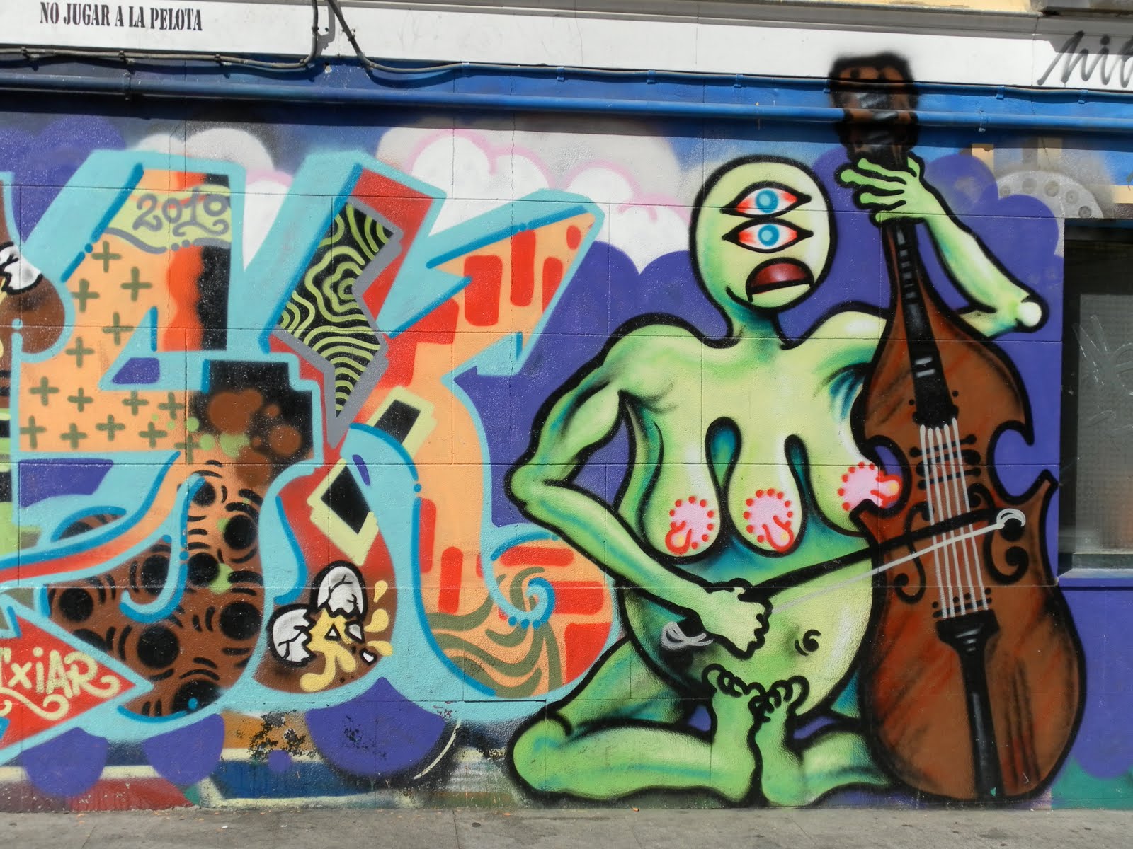
During my adventures through Madrid (by foot and by Metro), I noticed a large amount of paint on the walls of the buildings around me. Some of it was quite ugly and would be considered vandalism by most:


Other examples were more colorful, but would be considered "tags" by many:

However, a "tag" is a pretty negative term to describe the colorful work posted above.

There were many pieces that had tags on top of art on top of tags and onward. Everything became a multilayered piece of work:


And then there was this piece. It is obviously a tag but it made me laugh (value of positive emotional response) due to the resulting geographical juxtaposition of a boutique clothing store + the symbol of anarchy:


Then there were the residents/store owners: some mornings, they would be cleaning the scribbled text off the walls in front of their storefronts. Other retail establishments seemed to embrace the work done on their facade, or maybe they encouraged it in the first place. The store I saw with the most creative solution had a portion of their sign that said "Please do all graffiti here" with an arrow to a portion of the wall.

In the end, this entire situation leads to a question: How do authorities and governments pursue the issue of "street art"? Do they promote some of it and condemn other parts of it? Who makes that judgment call about what should stay and what should not? Does allowing paintings on buildings lead to "taggers" thinking they can mark the walls of the city as well? How much money is the Madrid police spending every year to "clean up" the ugliest of the tags?

In these specific neighborhoods (specifically Malasaña and Chueca), there seemed to be a good balance of the authorities respecting what looked like art and cleaning up the uglier tags.

In my personal opinion, the street art really enhanced the neighborhood. The vivid colors really brightened the narrow streets. It provided me with insight and perspective about the residents of the area. In addition, it helped me to understand the culture in existence without going inside a single residence.

However, I do not live in these neighborhoods; I am simply a visitor. I have a feeling a lot of the residents hate the graffiti, especially the older residents. I also thought about my parents house in Albuquerque; my parents would probably be appalled if any of these colorful forms of expression started popping up in upper-middle class Glenwood Hills.


This whole discussion goes back to the events that occurred just a few weeks ago in Albuquerque.

A few months ago, this beautiful piece of work popped up on the side of a Downtown building.

A couple more similar works popped up around town, but no one talked much about it. The small amount of local discussion I heard about it (through the comments on this post) was mostly positive (Why can't he paint my house?).

Then, the artist, nicknamed the "Rainbow Bandit" for his colorful pieces of self expression on private property, was arrested by APD. This occurred days after a great anonymous interview about him ran in a local "alternative newspaper" called the Alibi.

While I understand the motivation behind his arrest, I have no idea why APD was focusing on him. There are so many other taggers in the ABQ metro area that do some really ugly, crappy work. His colorful drip paint rainbows all over town were beautiful; one of them appeared on a post-crash half-build ugly skyscraper, making this eyesore that much prettier.

So, art or graffiti?

Saturday, August 28, 2010

Goodbye ABQ Ride, Hola España


I have not posted for a long time. This has been due to the fact that I have been extremely busy working at the ABQ Ride offices and preparing to study abroad in Alcala de Henares, España.

This summer, I had a paid internship at ABQ Ride. During my time there, I managed to accomplish my major goal: to resign the ABQ Ride System Map. To give you an idea of the major changes I made to the system map, here is the old one:


As you can see, it is hard to read, cluttered and complicated. Here is my new one:


If you want a direct link to the map on the ABQ Ride website, here is the location.

My priorities for the revised map were an easy to read key and cleaner, less cluttered lines. Another priority I had was showing a better distinction between the lower frequency routes and the higher frequency routes.

Interestingly enough, almost as soon as I was done with the new map, Jarrett Walker of Human Transit wrote a great post about the importance of frequency-based transit maps. Local blogger John P. of Carfree in 'Burque wrote a post in response to the Human Transit post; it included an ABQ Ride Frequency Map. Johns map happened to include many of the elements I added to the new map. This entire situation highlights the potential power of the interconnected Internet to influence ideas and policy.

Though I admit my new map is not perfect, it was the best I could do with the time and resources provided to me.

In addition, this summer I also created 4 other ABQ Ride maps for each of the major system transfer/transit centers: Alvarado, Uptown, Northwest and Central & Unser. Other than the Alvarado map, none of these maps previously existed in any form. I hope these documents can help people more easily navigate the ABQ Ride system.

This summer, I learned many things about life in the office, transit planning, politics, bureaucracy, transit funding, the City of Albuquerque, ABQ Ride and many other things. There is one very important point I would like to write about at this juncture; it is a major difference between the transit system in Tucson (SunTran, which serves an average of 13,534 daily riders) and ABQ Ride (which serves an average of 7,948 daily riders).*

Since both metro areas have a very similar population (and similar demographic indicators as well), one would expect similar ridership. What gives?

Local geography helps to explain the differences: in Albuquerque, the city is divided up by 2 major interstates (1-25 and I-40) + Paseo del Norte + the Rio Grande river basin; in Tucson, the street grid is relatively well connected, with the only major freeway (I-10) skirting the edge of town.

There is also another reason for the difference:

Regional vs. local.

Tucson has a single REGIONAL transportation system. This means that there is one service provider for all the local transportation needs. This makes sense, as Tucson is a relatively small isolated metropolis.

Albuquerque, on the other hand has both a REGIONAL and LOCAL transit provider: ABQ Ride is local, while Rio Metro (the group running the Rail Runner) is regional. This means that funding is DIVIDED between these separate agencies.

How can Albuquerque expect to create a seamless, efficient network when the cash is split up between two different agencies? Though this issue may not be the deciding factor behind the ridership differences in these two cities, I believe it is an important issue that should be discussed by local leaders. After all, I'm not sure Tucson would have received federal dollars for their modern streetcar project without the unified force of a REGIONAL transportation system.

This was my major observation about ABQ Ride vs. Tucson/Suntran vs. regionalism/localism vs. transit networks in general.


Anyways, that all has come to an end and I am now in Spain. I will be here for the remainder of the year, studying Spanish and other assorted things. I will try to blog as often as possible, but I will be studying full time so we shall see.

So, as always, IT'S TIME FOR A TRANSPORTATION REVOLUTION!

---

*All the data used was acquired from the Brookings Institute website from the interactive State of Metropolitan America Indicator Map. If you have not played around with this incredible interactive data set DO SO NOW! It is chock full of interesting, interactive demographic data from across the United States. Have fun!

Monday, July 5, 2010

Back At It from Urbanquerque


After not posting for over one month, I am trying to get back into it. I have had so many ideas and adventures that it has been hard for me to figure out how to turn them into some sort of written form. Alas, without trying there would be no success.

My living situation for this coming month is urban and unique: I am spending the month living yards away from the University of New Mexico (UNM) in a 1950's style suburban house in the Nob Hill neighborhood. My reasons for living down here are
a) my downtown summer job at ABQ Ride and
b) the fact that I am starting summer school tommorrow at UNM. I have no car for the summer so living in the far eastern part of theNE Heights with my family would be impractical.

The cost of living here in Albuquerque is extremely cheap. Since I am living so close to transit and bike-friendly areas, my transportation costs are ZERO. This is due to the fact that I am working at ABQ Ride this summer (they provided me with a free bus pass) and the fact that my father is letting me borrow his fantastic old-skool road bike.

My quality of life down here is amazing. I bike pretty much everywhere and go on long bike rides every evening as the sun sets and the earth cools down. I buy groceries (mostly from the nearby Sunflower Market) and cook almost all my own food, saving lots of cash. Basically, my only expenses are rent and the occasional grocery trip.

Most people believe that living carfree in burque is impossible; I am proud to say that it is entirely possible (in certain parts of the city) and continues to get easier.

Thursday, May 20, 2010

ABQ Bike Planning Open House: Some Great Ideas


Yesterday (May 19, 2010), I attended a meeting that discussed Albuquerques long-term plan for bikeways, trailways and other non-automotive infrastructure improvements (ABQ Bike Map [PDF]).

The Albuquerque Bikeways and Trails Master Plan Update is a series of meeting that will be occurring throughout the next year. They will be a series of discussions about the future of Albuquerque's bike and trail network.

The meeting yesterday took place at a library (Erna Ferguson Library for all you Burqueños). The format of the meeting was really good. Instead of some city officials just telling the citizens what they were going to do with our tax dollars, there were a series of interactive workshops. These workshops were staffed by the members of the consulting group hired by City of Albuquerque, Gannett Fleming West Inc. This consulting firm has teamed up with another firm, Alta Planning and Design. The people associated with this group, based in Portland OR, seemed to really understand how to create a comprehensive bike and trail network.

I remember one of the consultants from Alta discussing Albuquerque's potential to be a world class bike city. He listed these reasons:
1. Mild year-round weather
2. Lots of sunshine
3. A consistent grid-based street system (at least in the Northeast Heights)
4. Relatively flat terrain
5. The current existence of some great bike network elements

I have to say, the plan they have is pretty good and comprehensive. If they could fast-track many of these projects, I could see the mode share of bikes increasing by a large amount.


However, this will only occur if there are incentives not to drive instituted as well. Currently, Albuquerque, like the vast majority of American cities, is filled with developments surrounded by large free parking lots. As the great Donald Shoup once said, "There is no such thing as free parking." We all pay the costs of an automobile oriented built society. These costs include high bike and pedestrian fatality rates and long distances between places.

Having great bike infrastructure is essential, but in some ways, good planning and land use should be far more crucial long term goals.

Monday, April 26, 2010

CNM and ABQ Ride: Working Together?


For everyone reading this post not from Albuquerque, CNM is the local community college in the Albuquerque metro area. ABQ Ride is the local transportation agency in the city of Albuquerque.

CNM and ABQ Ride do not have best relationship.

Sure, there are a few ABQ Ride routes that access the CNM campuses. Sure, ABQ Ride acknowledges the existence of CNM. However, compared to the amount of support received from ABQ Ride by UNM, almost no attention is payed to CNM. After all, the 3 Rapid Ride routes all pass by UNM.

How many CNM campuses are served by even one Rapid Ride route?

Hint:0

A closer partnership between CNM and ABQ Ride should be a no-brainer:
1. CNM is the largest secondary education institution in the state
2. CNM students, just like UNM students, have free access to transit. One reason the Rapid Ride has been so successful has been the fact that it serves UNM, a huge bank of citizens with free transit passes.
3. Community college attendees generally have average lower income than UNM attendees, making them perfect candidates for improved transit access.

The reasons behind the lack of a partnership between CNM and UNM are understandable. First, UNM has one major campus; CNM has many campuses scattered across the city.

Here is a map of the CNM campuses:

As you can see, there are many campuses with many locations. This is significant because many students take classes at multiple CNM locations. For the purposes of this post, I will focus on the three largest CNM campuses: Main, Montoya and Westside.

Connecting Montoya and Main: The Montoya campus is currently poorly served by bus service. Main is also lacking significant connections.

The current bus situation for Montoya: Two routes nearby (the #1 and the #5), but none that are even close to the front door of the campus.

The current bus situation for Main: Two bus routes-the 96 Zuni (which only runs on weekdays, stopping at a frequency of once per hour) and the 16/18 BUG (which has an extremely inefficient convoluted route). Solutions to improve the 16/18 are discussed here as well.

My solution: 1 new bus route and 1 enhanced bus route.

The enhanced bus route would follow the current route of the 96 Zuni route, but it would be enhanced by having a significant amount of distance added to it. The majority of this added distance would be the continuation of this route along Morris until it reaches the CNM Montoya Campus.

The route would look like this:

View 88 Morris/Zuni in a larger map

The two place marks on here are the two existing CNM campuses that this route would serve.

The benefits of this alignment are discussed in further detail in this previous post.

The other route I propose is a Rapid Ride route along Montgomery and University Blvd. The southern terminus would be the airport and the eastern terminus would alternate between CNM and the Montgomery/Tramway Park and Ride (on weekends, all the Rapid Ride trips would end at Montgomery/Tramway and on weekdays, the terminus would alternate between trips).

The route would look something like this:

View 725 Montgomery/University Rapid Ride in a larger map

Once again, the place marks designate CNM locations. This route also serves UNM and the UNM Hospital, which is growing very rapidly. This route would complement the current #5 route along Montgomery. This is similar to a route I proposed on this Duke City Fix post, which was then later discussed on this post.


Connecting the Westside campus to the ABQ Ride System
: Currently, the Westside campus is served by zero bus routes. This is understandable, considering the sprawling nature of its location. However, it is relatively close to the Northwest Transit Center, making it a good candidate for the terminus of a regular weekday route with half hour frequency.

The route would follow this alignment:

View 101 McMahon/Ellison in a larger map

The marker on the left is the Westside CNM Campus, and the marker on the right is the Northwest Transit Center. This route would be guaranteed success, based on the theory of anchoring transit lines discussed in paragraph five of this post:
So transit planners are always looking to anchor their lines. Anchoring means designing a line so that it ends at a major destination, so that there will be lots of people on the vehicle all the way to the end of the line. A line with strong anchors at each end will have more uniform high ridership over the whole length of the line, and a much more efficient use of capacity overall.


Let's review:

Currently, all CNM students, and all UNM students, have free ABQ Ride bus passes.

CNM needs to have a closer relationship with ABQ Ride.

Three (3) new bus transit lines would vastly improve this connectivity.

Monday, April 5, 2010

What Methods Can We Use to Prevent People from Buying a Car in the First Place? 1. Carsharing

I would like to start this post with a disclaimer: I am not an anti-car person, and I never will be.

Motor vehicles are amazing inventions. They increase mobility for the users and allow owners of cars to go wherever they want whenever they want.

However, there are a few drawbacks to a car oriented society: not everyone can afford one because they are expensive to maintain. Also, since our entire build world has become so motor vehicle centric, not owning a car has become a major disadvantage. Our roads are overcrowded, so how can we prevent people from needing to buy a car?

I say "need" because many times, cars are not bought on a "want" basis. Though many times they are, plenty of people buy cars based on "need".

People buy cars if their transportation needs are not adequately met by transit, walking, biking or car sharing. Most of America fits into this category, so it makes sense that most Americans own cars.

Why do I want people not to buy cars?

Well, this is how it usually goes: once someone buys a car, all they use is a car. They no longer consider using buses, bikes or walking because a car is such a large investment. It doesn't make sense for someone to make a large investment for something they will use occasionally. Also, our modern build world reinforces high intensity vehicle usage. When someone buys a car, they reinforce this entire cyclical system.


Though the solution to this problem is multifaceted, I see car sharing as the most important solution to this problem.

I would like to use my own personal life as an example.

I do not own a car. Though I had one when I attended high school in Albuquerque, my brother now uses that car so I have no car out here in Tucson. I have no problem with not owning a car. I enjoy biking to school most days because it stimulates my mind and gives me exercise. On the days when I do not feel like biking (sick, raining, windy, lazy, etc) a bus route passes very close to my house and takes me directly to campus. This bus route is pretty good, as it comes every half hour on weekdays from 5 AM to 10 PM. Since most of my time is either spent on campus or at home, the bus and bike connections work very well for my commute.

But what about everything outside of my daily commute?

Most American driving miles are no longer the simple commute to and from work or school. People need to get to baseball practice, the mall, Baskin Robbins, the movie theater, concert and a billion other locations and events. In most cities, since everything is so spread, you sometimes truly do NEED a car to get to many of these locations.

For example, I need to buy groceries once a week. I prefer going to Trader Joes, which is too far to bike to and inaccessible by bus. Luckily, I have some awesome roommates who let me borrow their car once a week for this journey.

Alas, most people do not have my awesome roommate situation. It is at this point when most people decide that they must own a car. It is these kind of journeys that need to be tackled in order to reduce car purchases. Car sharing is the answer.

How does car sharing work? The most popular car sharing program in the nation, ZipCar, works like this: cars are distributed in a given area. People in this given area sign up for a membership. When members want to use a car, they get on the Internet (or iPhone), find the closest one, scan the car with key less entry, and go for as long as they want. The longer they go, the most they have to pay so there are incentives for people to bring the cars back ASAP.

Now, if there was a bank of these cars in my neighborhood, I would totally sign up. I would not be the only one, as my neighborhood is filled with lower income car free dwellers. The problem is, Zipcar is still a for-profit company. They will only expand into areas where profit margins are high and risk is low. Central Tucson is probably not high on their expansion list.

This is why Ray LaHood and livability proponents need to start doing more work to get local car sharing programs jump started. I am so happy to see the federal DOT give so much more credit to bikes, pedestrians and transit, but these solutions will only go so far. Car sharing should also be a big part of their push for livability.

Though car sharing still involves cars (which I am not a huge fan of) they are an essential part of any solution in society that has only been building car based for at least 70 years. Honestly, they are the most realistic solution to getting cars off the road. Just look at this infographic, and this article (both from FastCompany), for proof.

Let's stop the cycle of people needing to buy cars; add car sharing to a growing list of great solutions.

Tuesday, March 16, 2010

Q: Why Does Nobody Walk?

A: There is nowhere to walk to.

In my neighborhood in Albuquerque (Far Northeast Heights), I just went on a walk. As I was walking, I decided to estimate how large each house lot was: 33 of my steps. This means that only about 2-5 people live within 33 steps worth of street frontage. In this situation, a lot of street frontage is required to create enough density for any business to be successful. Though there are nice smooth wide sidewalks throughout my neighborhood, nobody uses them unless they are walking their dog. The closest services are located in a strip mall at the bottom of a large hill.

People will not walk if there is nowhere to walk to.

In contrast, my neighborhood in Tucson has no sidewalks, but many people walk through this area. This is because there are places to walk to. There are two bus routes that intersect a block away. There is a taco shop, offices, a haircut place and two food stores on this same intersection. The lot sizes are smaller, and the roads are arranged in a grid, which allows for easier walkability.

Even though my neighborhood in Tucson does not have the proper facilities for walking, MANY people walk through it because there are places to walk to.

Sidewalks are not important. Destinations are.